Friday, July 13, 2018

A Quick Run Around the Block


  I decided this week that I'd head up into the Angeles National Forest and see what I could see. I packed all the usual camera gear, and the drone, hoping to get some good overhead tree/mountain footage.
  I left at 5:20 in the morning and made my way up to Palmdale mostly under cover of darkness, and then turned and headed east along the Pearblossom Highway. It's a pretty unremarkable stretch of road unless you enjoy endless dusty fields of Joshua trees.
  Finally, I arrived at the turnoff to Highway 2, the Angeles Crest Highway. It twists and turns along the spine of the mountainous Angeles National Forest, and makes its way through a couple of small ski villages. I bet it's really beautiful when there's snow on it.
  What I noticed first was the smell. I had my windows about halfway down, as temps were in the mid 60's even at this early hour. Suddenly, the sweet, sweet smell of forest was everywhere. Immediately, I was taken back to not only my childhood home in the mountains, but many, many camping trips. That fresh, clean, piney air is something I wish I could bottle.
  After I passed through a couple small ski villages, the road started climbing pretty quickly. As I came around one corner, a sprawling view opened up to the right. I pulled over and decided to get the drone out and capture it!
  A few minutes later, as I was cursing a blue streak and packing the drone back up, my mind was racing trying to figure out what was wrong. BOTH batteries were non-functional. And when you drop $115 per battery, they damn well better work. One of them has only flown ONE TIME.
  (To digress for a moment, when I got home hours later, I found out that the batteries are programmed to de-charge themselves after three days of non-use. I charged these two weeks ago, when I thought I was going to make this same trip.)
  So, I continued onward and upward, figuratively and quite literally. A few turns down the road, a healthy looking coyote ran across the road after a rabbit. I had the road entirely to myself, so I just jammed the brakes and whipped onto the shoulder, scrambling for my camera. I managed to get a couple shots of him as he trotted away. He didn't like me, and he didn't like that I interrupted his breakfast. Coyote 0, Bunny 1.

 
  This sudden pulling over and taking pictures continued almost constantly for the next couple of hours. View after view after view. Really a lovely drive. I saw so many critters.

Some kind of blue jay maybe

friendly fella

 I took a lot of scenery pics, but I'm trying to save those for Instagram. If you're not following my photo account @photo_bastard, then you should be.

  About halfway through the drive, I spotted a kind of rocky canyon below the road on the right. It looked like there was a narrow ridge jutting out toward it, and it looked like a perfect hiking/exploring adventure. I pulled over, sunblocked up, grabbed my water and gear, and headed out.
  It wasn't too far to the end, which was a massive crag of rock sticking up over the canyon floor. I put everything in my pockets so I could have both hands free, and climbed to the top. It was a great view! Here's a few seconds of phone video:


  Though the view was good, what happened next was even more incredible. Two hawks showed up and began to fight. Now, not being any kind of expert on birds or their behaviors, I couldn't tell if these were rivals or lovers. Whatever was going on, there was a lot of flying around and screeching. It was really incredible. Because the outcropping I was sitting on wasn't very wide, and I don't enjoy falling to my death, I laid on my back with the camera pointed straight up and started shooting.


  After I shot a billion pictures (focusing was really difficult) I packed up my stuff and got back on the road.

  Gradually, as I got lower in elevation, and began to get nearer to Glendale, the scenery kind of tapered off. There were still mountains, but a majority of the trees were gone. In their place were charred, withered remains. The victims of one of our many wildfires. Sad.
  And just like that, I was out of the clean mountain air and back into the smoggy, dirt and oil smelling city air. I'll definitely be going back, if only to get that drone footage I missed out on. Besides, according the map, there's another fork in that road that I didn't explore.
  Til next time.

.

Saturday, March 3, 2018

Adventure Has a Name, Part 2


 Now, where were we? Ah, yes, I had just come down from Angel's Landing, missing a few things, but otherwise intact.
  Before I could go back to the hotel for some much needed rest and a hot beverage, I had to drop by Zion Adventure Company to rent some gear for the next day's excursion. I'm putting them here as a link in case any of you other intrepid adventurers need some gear when you're in the area. I highly recommend them.
  I watched a short film on The Narrows, my destination for Saturday, which discussed the very real possibility of hypothermia. Protection can only go so far, and you're pretty much done if you end up submerged in the icy waters of the Virgin River. Stay upright. Got it.
  The guide at ZAC gave me river shoes that were two sizes too big so we could double up on the neoprene "socks" that I'd be wearing to protect my feet. After explaining the ins and outs of how to suit up, she rang up my rental package: drysuit, shoes, neoprene socks, walking pole. Have it back before 6:00.

DAY 2

Missed Connections

  After wolfing down another free breakfast, just after 7:00am, I went back to my room to get ready for the day. It was 22 degrees.
  Putting the drysuit on was a little tricky. The rubber gaskets at the ankles were very tight and hard to get over my feet. As was recommended, I left the top half off and simply tied it around my waist. It would eventually go over all my layers and my jacket, once I got to the river's edge. I imagined I was going to look like a very colorful Michelin Man when all was said and done.
  The only kink in the morning was that I was being forced to ride the park shuttle. Friday had been open to private vehicles, but on the weekends, guests had to ride the shuttle into the park. I checked the map and saw there were several stops right there in town.
  So, into the morning air I went, hiking through the town toward Zion. It seemed to take forever, and I wasn't finding the stop. After a good 25 minutes, I happened upon a construction worker. "Do you know where the shuttle stop is?" I asked, huffing out steamy breath. "Shuttles don't run in town yet. You gotta catch it inside the park," he said. Might've been good to know ahead of time.
  Once I was Jeeping down the road, minus about 45 minutes of my morning, things got back on track. I parked at the visitor's center and caught the shuttle immediately. Hardly anybody was aboard. I mean, what kind of maniac would go hiking in this cold? Especially in a river?
  The shuttle, which stops at every single spot in the park, took a while to get me to my stop, which was last on the route.

The Temple of Sinawava

  This last stop had a really cool name: The Temple of Sinawava. It sounded like something from Indiana Jones, and it kind of was. Eventually.
  First, though, was a long and rather boring "riverwalk" trail that, while I'm sure is very beautiful in springtime, was kind of unremarkable on that day. Maybe it was just me. Maybe I was just really in a hurry to get to the river. Probably. Definitely.
  Finally, I arrived. The trail abruptly stopped, and there were a few stairs down to the rocky shore. Only a husband and wife were there, and they were just taking pictures.

Entry point into the river
 
  I untied my drysuit and attempted to slip it up over my shoulders. There was a gasket at the neck as well as the wrists, and they were all just as tight as the ankles. The suit was so difficult to get into (likely because of my bulky jacket) that I began to wonder if I was going to be able to get into it at all.
  After much struggling (and some odd looks from the photo couple), I eventually poked my head through the opening and managed to get my shoulders planted into the suit. The heavy duty gasketed zipper that ran diagonally across the chest was also quite difficult, but I struggled until I got it.
  Time to step into the river. It was 18 degrees out, and the water temp was a brisk 39.

Stepping in

  I wasn't tentative with those first few steps. I figured I might as well wade right in. To my surprise, though, I felt my shoes immediately fill with water. "Uh oh," I thought. I waited for the pain or numbness in my toes, but it never came. The water wasn't shockingly cold as I had expected. It was merely cool. I figured that what I was feeling was just the temperature of the water against the neoprene, and that my skin was safely dry beneath the layers.

Phone selfie

  Hiking in the river was difficult. The bottom was rocky and uneven most of the time, with only a couple rare instances of a sandy bottom. Most of the time, the water was about knee deep, which was tiring to walk in. Between the depth and pushing against the current, it felt like I had weights strapped to my ankles. I was very glad for the pole, though, because without it, I would surely have fallen.

The Narrows

  As I hiked on, turn by turn, hour by hour, the canyon got increasingly narrow and dark. It was really something to behold. Sadly, pictures cannot do it justice. You get no sense of how it felt, how it sounded (I purposefully didn't have headphones in) or how impressively tall those walls were. Just amazing. 
  In some places, the water was waist deep. I passed by others that looked to be about shoulder deep, and I steered well clear of them. I still felt very comfortable, temperature-wise. In fact, I eventually took my wool hat off and put on my ballcap, because I was sweating so much.


  I did run into a man and his son at one point. They only had waders on, not full drysuits like I did. They were in good spirits, though, even though the father complained that his hands were freezing. It was only long after I left them that I realized I had some handwarmers in my backpack. Bad neighbor.

Turnaround

  After passing through many beautiful bends in the river, snowy shores, giant icicles clinging to the rockface, and never a trace of sun, I finally reached my predetermined turnaround spot. I could have gone further, but I had already traversed the narrowest part of the river, and felt no need.
  I took my pack off, drank what little water I had that wasn't turning to icy slush, and ate two granola bars, which were frozen solid. Sitting there, in the shade of the canyon, relatively still, I got cold for the first time.

The Return

  On the way back, I could tell that fatigue was starting to get to me. My hip joints were getting tight from dragging my legs against the water, and my feet were getting a little achey from constantly stepping on uneven surfaces. I had also started to slip more when crossing swifter portions of the river, and almost fell a couple times. Each slip wore me down a little more.

  I was able to quench my thirst, though, when I ran across a large ice shelf that was melting and dribbling water into the edge of the river. I held my bottle underneath the ice for a few seconds and was rewarded with clean, clear, crisp water. It did the trick and helped perk me right up.
  Toward the end/start of the trail, I ran into a handful of other industrious folks just beginning their trek upstream. Other than that group, there really didn't seem to be a lot of interest in The Narrows during those chilly conditions.

Back to Civilization

  Finally, I made it ashore, where there were considerably more people. A few of them gawked at me climbing out of the river like I was some kind of creature of the deep. I had less struggle getting out of my suit than I had getting in, but it still wasn't at all easy.
  After catching the shuttle and making all the stops, then Jeeping back to the hotel, I was finally able to fully un-gear my body. It felt great to get unbundled, and I was shocked to find that my shoes AND the neoprene booties were full of water. My feet had indeed been wet the entire time. Amazingly, though, they were so well insulated, that it only felt moderately cool and not frostbitingly cold.
  And so, I returned the gear, thanked the shop, and came back to the hotel for a nice, warm, relaxing evening.

The End 

  Just like that, the Zion experience was over. There was still so much more of the park to explore, but I felt very accomplished at having conquered Angel's Landing and The Narrows, both during some pretty harsh conditions.


It had been a beautiful adventure, and I knew, as I drove away the next morning, watching the first golden rays of sun play across those tall peaks, that I'd be back someday.


.

Wednesday, February 28, 2018

Adventure Has a Name


  And that name is Mukuntuweap. At least, it was, until it was changed in 1918 to "Zion." Apparently, the acting director of the National Park Service thought the moniker, which was the original Paiute name, was too foreign and hard to pronounce. At least the name he chose reflected the great reverence for the area that every single group of folks held for it since it was first inhabited.

  But I digress. Let's to the adventure part, shall we?

Getting there

  Since my trip to Zion National Park was going to take me very close to Nevada's Valley of Fire State Park, I just had to add it into my itinerary. It absolutely did NOT disappoint.
  After a long, winding road through a fairly unremarkable parcel of desert, I came over a hill, at the bottom of which stood the entrance gate to the park. Beyond it was my first glimpse at the valley's "fire." A huge swath of gorgeously bright red rock jutted out of the earth, reaching jaggedly skyward. "WOW," I said aloud.


  I paid my entry fee, drove a short way in, and then began a long series of constant pulling off the road to shoot the fascinating landscape. I had seen red rock before- plenty of it in Utah, in fact. This was somehow different.
  I knew that somewhere in the park was a famously photographed stretch of road that cut right through the middle of the rough, tumbled terrain. I wanted that picture, or one like it. Soon enough, I found that stretch of road, just on the other side of the visitor's center.


  Just a short distance further was a small parking lot that was the jumping off point for several trails. I pulled in a took about a billion pictures of the area. Some of the best shots I got were from high atop a narrow piece of rock, where the views stretched deep across the desert. All sorts of shapes, sizes, and colors of rock collided in glorious ways.


  A couple more miles down the road, I did a short hike to a feature called "fire wave." It was an area where erosion had exposed alternating red and pink bands of sedimentary layers in the rock, giving it a fiery, flowing appearance. Like much of this landscape, it looked like something from another planet.


  The day was wearing on, and I still had a good couple hours drive to make it to Zion, so I skipped a lot of the park and headed out. Still a lot left to explore there if I'm ever passing through again.

  By about 6:00, I made it into Springdale, Utah, and checked into my hotel for a good night's sleep before the big day.

The First Morning

  It was below freezing that morning, as I knew it would be from weather forecasts. It had also snowed, as predicted. I drew the curtain back for my first daytime look at the canyon. The sun had yet to make it very high, but I could see the soft blanket of white covering the tops of the towering rock faces. Gorgeous.


  I almost fell down a couple of times on my way across the parking lot to have breakfast. Before the snow fell, it seems, a nice coating of ice had been laid down by freezing rains. It didn't portend good news for my climb to Angel's Landing.
  After a quick and delicious (free!) breakfast, I jumped in my frosty Jeep and headed out to see what was what.

Into the Park 

  At the entrance gate, I asked the ranger if anything was closed due to the conditions. She said that all the upper trails were not advised, as they had been hit hardest with ice and snow. That included Angel's Landing. 

A Snowy Detour

  So, I thought, she didn't specifically say "closed." Just not advised. Well, I decided I would judge that for myself.
  I drove on into the park, marveling at the snowy wonderland all around. There were so many times I wanted to stop and take a picture, but I really just wanted to get to the trailhead and figure out what I was going to do.
  The road took me on and on, winding back and forth up the side of the mountain. Strange, as I would have imagined the trail to start on the valley floor. I became too preoccupied though, with finally giving in and getting some photos to give it much thought. The sunlight was just starting to peek in, and it was undeniably a photo bonanza.


  Once I reached the Zion-Mount Carmel Tunnel, I realized I had indeed taken a wrong turn somewhere. There had been a fork in the road a couple miles back, and I probably missed the sign while taking in all the beauty around. I wasn't upset, though. It had been a fantastic detour.

  Once I was back on track, I was presented with even more photo opportunities. The beautiful Virgin River wound its way down the canyon to my left, surrounded by snow covered trees and boulders. I desperately wanted to stop, but I was already behind.
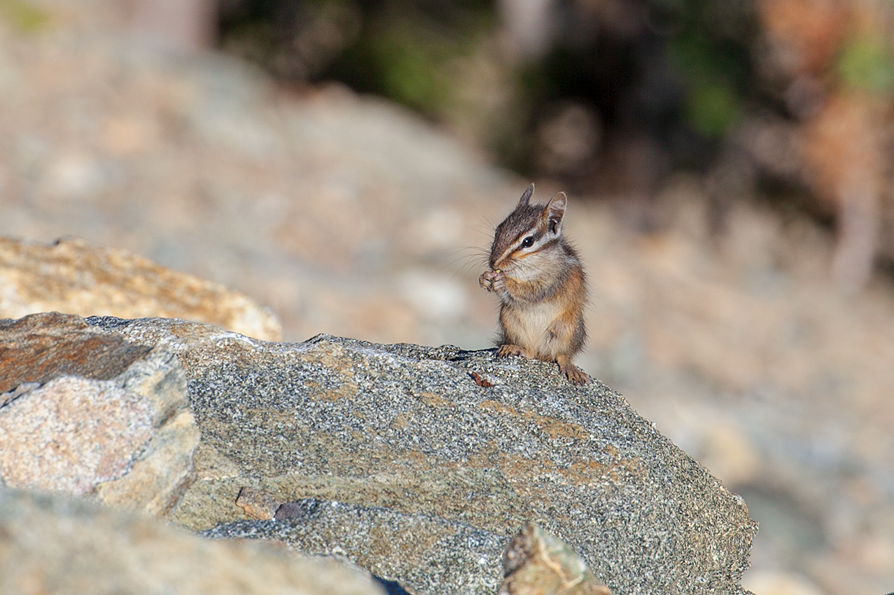
  I also passed by a rafter of wild turkeys. Not as majestic as a landscape photo, but I still wish I could've grabbed a shot of them.


The Trail to Angel's Landing

  Finally, I arrived at The Grotto parking area, which was the starting point for the Angel's Landing trail as well as several others. There were only about four cars in the lot, which wasn't surprising. It was only 27 degrees, and hazardous conditions.
  I suited up, stuck my headphones in (adventure playlist, of course), headed across a bridge, and entered the trail.
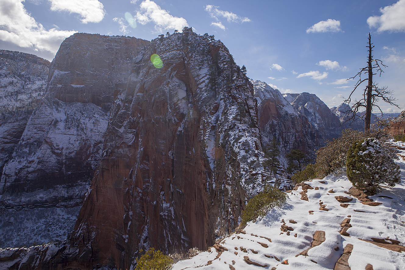
  It was really easy going at first, but, naturally, it got steeper and steeper the further I went. Looming in front of me was all 1500 feet of Angel's Landing. I was determined to see the top of that enormous piece of rock today. Safely determined.


  There was nobody on the trail. Total quiet. Someone had been there, though, because there were a couple sets of tracks in the fresh snow. Maybe three sets?
  About halfway up the switchbacks, I heard someone approaching me from the rear. I looked below and saw that a guy was gaining on me. One of these "fast hikers," or at least someone in better shape than me. Soon enough, he caught up to me as I was catching my breath in a little nook. We introduced ourselves and commented on how nice it was to have the trail so empty. He, like me, was going to go make his own judgement about how sound the trail was toward the top. "See you up there," I said, and he went on.
  Mercifully, the switchbacks ended, and I was back on relatively flat ground. I thought I must be getting close to Scout Lookout, which was the last stop before the beginning of the Angel's Landing ascent. But, then, surprise! MORE switchbacks. A lot more.

Stock photo of Walter's Wiggles

  This was the part of the trail known as "Walter's Wiggles." I thought the switchbacks I had already come up were Walter's Wiggles. Nope. These 21 steep inclines I was looking up at were the famous wiggles. And they were covered in a thick layer of ice.
  I took my time, stepping very carefully. I made sure every plant of my feet had good purchase before putting weight on it. Even so, about two thirds of the way up, the ice got the better of me and I fell. I fell all the way to the ground and slid on my ass to the bottom of the switchback. It wasn't a dangerous fall, as there was nowhere to go. It was just frustrating. I re-climbed the slippery slope and continued on, eventually topping out the wiggles.

Scout Lookout

  The ground then leveled out once more, and I found myself at Scout Lookout. A small sign showed the way to Angel's Landing, which, even at this high point, still towered above. The sign also warned of the potentially fatal risks involved with the climb, moreso during conditions like the ones we were facing today. I say we, because there was my fast hiking trail pal up ahead, talking to a couple who had just come down from Angel's Landing.


  I joined the conversation as they were discussing how they only managed to go a slight way up the exposed rock trail before deciding it was too risky. They said there was only a single set of footprints leading up from there. One brave/foolish soul.
  So the two of us big dreamers were left there. As I took another moment to rest up before the challenge ahead, he went to check it out. He came back just a couple minutes later and said "Yeah, that looks pretty sketchy."
  Now, my idea of sketchy and your idea of sketchy might not necessarily match, so I decided to go have a look for myself.


  It looked daunting, yes. It looked challenging. It did not look impossible to me at all. "I'm gonna go for it," I told my companion. "If it gets too bad up there, I'll just turn around." He decided to join, and so off/up we went.

The Ascent

  It really wasn't too bad at first. There was a chain bolted into the rock to hold on to in most places. I say MOST. There were a couple of less than ideal spots where a chain would have been nice. The dropoffs on either side of the trail kept getting taller and taller. Some of the sections were so steep, I was relying much more on upper body strength and using the chain like a climbing rope.
  Slowly but surely, step by step, foot by foot, we made our way up the narrow fin of snow covered rock. I'm not sure how much time passed, but then...

Angel's Landing

  The trail suddenly flattened out. We had made it to the top. We walked across the summit to the northeast face, which overlooks the entire valley.

  That view.


  I could definitely understand why they called it "Angel's Landing." The view was indescribable, especially with the layer of snow coating everything. Absolutely stunning.
  I stayed up there for quite a while, soaking it up, eating some snacks, drinking a little water. Just before I got ready to head down, another group arrived. They all had crampons on their boots and were aghast that we had attempted this climb without them.


The Return

  As predicted, the descent was trickier. Putting all my weight on the steep, snowy, now tracked-over and packed down trail made for some unsure footing. I ran into a couple on the trail and managed to find a spot wide enough to stand aside as they passed.
  A short distance down from there, though, I fell. A good, solid fall, on a fairly narrow section. I had taken my gloves off, because I was sweating pretty profusely, and my skin had shrunken closer to my bones. This was just enough room for my already slightly loose wedding ring to become extremely loose. It sailed off my hand and into parts unknown. I dug around in the snow for a good long time before I sadly consigned it to oblivion.

  At Scout Lookout, a few more people had arrived and were trying to decide whether or not to go on up. The small amount of people who had now ascended had made the entire trail worse. Walter's Wiggles was even more of a packed down icy mess than before. Some folks who had already turned back were opting to just sit down on each leg and slide on their butts. That wasn't helping conditions, either.
  Nonetheless, I made it down without incident, past the wiggles, over the flat section, and down the other switchbacks, feeling accomplished the whole way. Toward the valley floor, I saw a herd of elk in the distance. A second snowstorm had begun to move in, and a few tiny flakes began to fall from the sky.
  I stopped at the bottom of the trail, on the bridge that crossed the Virgin River, to snap a couple photos. As I pulled out my camera, I somehow knocked the lens cap off, and it fell into the river and was swept away. I cursed the luck, then went to switch lenses for a wider shot. As I did, I dropped the OTHER lens cap, and it, too, rolled right into the river.
  Aside from the major loss of the ring, and the minor loss of the lens caps, it had been a rousing success, and I had some gorgeous photos to prove it. Tomorrow, I'd hike The Narrows, another challenging trail.

  I'll write about that one in Part 2.

.